Dark? Cloudy? Snowy? ‘Synthetic aperture radar’ satellites can peer through it all, and this new sector is booming
Imagine a satellite image. You’re probably thinking of something taken by a high-res camera pointing down at the Earth—a bird’s-eye photograph. And that can be immensely useful for everything from navigation to city planning, but it has limitations. At any given moment, about half the planet is cloudy, and about half the planet is under the darkness of night. For real-time events, having the capability to “see” any point on the planet whenever you want to see it is incredibly important.
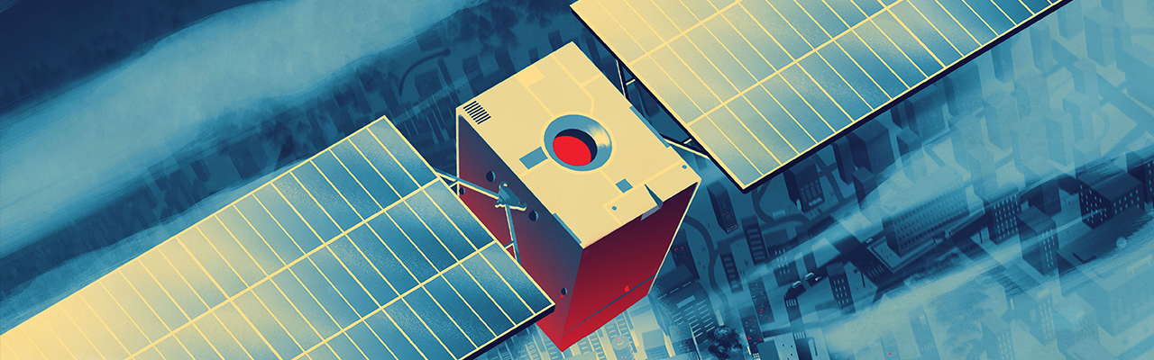
That’s why an alternative way of looking at the Earth has recently been making waves in the commercial world. Synthetic aperture radar (SAR) satellites don’t have lenses but radio antennae. These send out electromagnetic pulses and record the echoes as they bounce off the Earth’s surface. The echo data is then processed to produce an image. Because those pulses have much longer wavelengths than visible light, they can penetrate the likes of cloud cover or snow, and darkness is irrelevant. This means that multi-dimensional images of the surface’s structure can be taken at any time without fail, enabling persistent observation.
A number of companies are now running SAR satellites and offering access to their data “as a service” across a range of fields. “It is especially useful for environmental monitoring, for example, particularly to chart deforestation,” says Shay Strong, Vice President of Analytics for SAR satellite-operator ICEYE. “Rain clouds make this difficult in locations like the Amazon.” The technology has also assisted in the monitoring of natural disasters, such as volcanic eruptions or earthquakes. The SAR sector is currently in a growth phase, with one estimate forecasting the global SAR market size hitting USD10.7 billion by 2032.
So how did we get here? Governments developed SAR decades ago, originally for military surveillance. But several powerful and persistent trends have led to this imagery now being made available to a broad array of business customers. For most of the history of spaceflight, only governments and traditional space contractors could afford to build satellites. They were large and complicated spacecraft, often costing hundreds of millions to billions of dollars. But no longer. Just as technology has trended smaller on Earth in recent decades, with miniaturization leading to powerful computers sitting in our pockets, so too have satellites gotten smaller. In addition, companies have started taking a more commercially minded approach toward building satellites, using off-the-shelf components and designing more for efficiency and cost.

Another key trend is the diminishing expense and time involved in getting a satellite into orbit. The advent of private rideshare rocket rides has been a game-changer. Dozens of small satellites can be bundled together on a single launch, splitting the cost among many customers. The end result of all of this has been an influx of new companies and private capital aiming to disrupt low-Earth orbit with commercial satellites that can offer valuable services for the planet’s inhabitants. It is the boom area of the emerging space economy.
New markets have duly coalesced, but until recently Earth observation services have depended mainly on visible light. That changed around five years ago when the first private companies to offer SAR opened for business. Finland’s ICEYE, which has raised a total of USD304 million in funding, was one of those companies.
Today, the company has a constellation of 27 SAR satellites. Putting aside the difficulties of working with sensitive components and overcoming computational challenges, this kind of radar imaging is inherently complex because it has to work around a fundamental physics problem. Theoretically, producing high-resolution images from very long-wavelength radio waves requires a huge antenna (in the jargon, a huge “aperture”)—in fact, one so enormous it would be impractical. That’s where the “synthetic” bit of synthetic aperture radar comes in. As the satellite moves over a target, it receives multiple echoes. By combining these into a single image it can achieve clarity equivalent to having an aperture as large as the distance the satellite has traveled in that time. And that is the key to a further advantage of SAR. Since it is able to map the physical structure of the Earth at such high resolution, comparing two images of the same target can reveal surface changes on the millimeter scale.
ICEYE offers this data to organizations engaged in everything from managing floods and wildfires to monitoring sea ice or ports. It has proven especially valuable to insurance companies trying to make claims assessments following a natural disaster.
“The big insurers spend a tremendous amount of money to send a person out with a clipboard to check the aftermath of an event,” says ICEYE’s Shay Strong. “And it happens not just for floods, but after fires and large wind-storms. It’s fraught with uncertainty because you’re sending out someone who could be tired and rushed, perhaps making accidental biased decisions. ICEYE is helping to automate this process through quantitative observations so insurers can be faster to respond to clients, and pay claims more equitably.”
Initially, the focus for ICEYE was developing the radar technology and deploying it into space. The company believed it would just sell the data raw. But pretty quickly, says Strong, ICEYE realized that the true value lay in applying machine learning and additional analytics to help companies and governments get actionable information out of that data.
“Unlike with an optical image, few people understand the complexity of the information they’re looking at in an SAR image,” says Strong. “It looks and feels like an optical image in many ways. But there’s a tremendous amount of challenge with interpretation of the underlying physics.” And as ever, where there are challenges, there are opportunities. “What we’re doing now, is making that data more useful—and I think we are going to see continuing advances on that side of the equation. In particular, identifying and then building the critical solutions that benefit from this information. SAR imagery, and the solutions leveraging it, is a mechanism to quantify the impact of the changing Earth.”
Why ‘living off the land’ will be crucial to the dawning era of space exploration
As humanity ventures further into the solar system, harvesting resources in space for use off-world will be essential
Are space-based solar farms the future of clean energy?
The idea is enjoying more attention than ever—but there are major challenges to overcome

How celestial ‘gas stations’ could unlock the space economy
Orbiting propellant depots are in development, and they could reinvent how we operate beyond Earth

Space junk is a huge problem. It’s also a business opportunity
The more we do up there, the more we have to clean up after ourselves. But how?